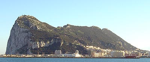
Small British peninsula dominated by the Rock of Gibraltar.
Gibraltar is a small British overseas territory on a peninsula at the southern tip of the Iberian Peninsula, beside the Strait of Gibraltar linking the Mediterranean Sea and Atlantic Ocean. It covers about 6.5–6.8 km², with a 1.2 km land border with Spain and 12 km of coastline.
Gibraltar is a British overseas territory on a small peninsula at the southern end of the Iberian Peninsula, by the Strait of Gibraltar, which connects the Mediterranean Sea with the Atlantic Ocean. The territory covers about 6.5–6.843 km² and has a 1.2 km land border with Spain. On the Spanish side of the border lies the town of La Línea de la Concepción. Together with neighbouring Spanish areas it forms part of the Campo de Gibraltar comarca. Gibraltar’s coastline is 12 km long, washed on the east by the Mediterranean and on the west by the Bay of Algeciras. Most of Gibraltar is occupied by the Rock of Gibraltar, a monolithic limestone promontory rising to about 426–427 m, connected to the Iberian Peninsula by a low, sandy isthmus. The western slopes are gentler than the eastern slopes, and low-lying areas are concentrated mainly along the coast. The eastern side includes Sandy Bay and Catalan Bay; most of the population lives on the western side. Gibraltar has no formal administrative division, but seven main residential districts are distinguished, including the Upper Town, Town, East Side, Reclamation Areas, North District, Sandpits Area and South District.