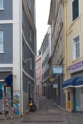
Street named Crutchett's Ramp in Gibraltar’s central urban area.
Crutchett's Ramp is a street in Gibraltar, a British Overseas Territory at the southern tip of the Iberian Peninsula. Identified as a ramp, it forms part of Gibraltar’s street network within the territory’s main urban area. The street is documented with mapped coordinates and photographic imagery.
Crutchett's Ramp is a mapped street in Gibraltar, recorded as an instance of a street located within the territory of Gibraltar. The name indicates that it is a ramp, and it appears within Gibraltar’s built environment. Information associated with Crutchett's Ramp includes a specific coordinate location and an image file named “Gibraltar Crutchett's Ramp from Lynch's Lane.jpg,” which shows that the street can be viewed from Lynch's Lane. The street is part of Gibraltar’s system of streets and public ways, and its identification in structured geographic data confirms its existence and position within the territory. Crutchett's Ramp is listed as being in the administrative territorial entity of Gibraltar and in the country of Gibraltar. Available data emphasise its classification as a street and provide its geographic coordinates and photographic documentation. Further historical, architectural or functional details are not included in the available sources, but the documented attributes firmly establish Crutchett's Ramp as a recognised street feature within Gibraltar’s urban landscape.