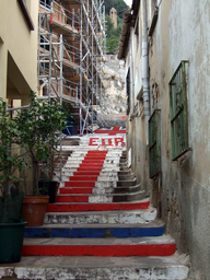
Street in Gibraltar with Union Jack Steps celebrating 1967 referendum.
Devil's Gap Road is a street in Gibraltar, also called the Union Jack Steps or Referendum Steps. It runs between Flat Bastion Road and Baca's Passage and is the quickest walking route from the city centre to the Upper Rock Nature Reserve, linking to the Devil's Gap Footpath.
Devil's Gap Road is a street in the British Overseas Territory of Gibraltar, also known in Spanish as Escalera del Monte. It runs between its junction with Flat Bastion Road in the south and Baca's Passage in the north. From its meeting point with Baca's Passage, the Devil's Gap Footpath continues upward and joins Green Lane near Devil's Gap Battery in the Upper Rock Nature Reserve. The road is described as the quickest route on foot from Gibraltar’s city centre to this nature reserve, making it a key pedestrian link between the urban area and the Upper Rock. The street is widely known as the Union Jack Steps or Referendum Steps. The steps on Devil's Gap Road were originally painted in 1967 to celebrate Gibraltar's first sovereignty referendum that year. Ever since that referendum, the steps have displayed the Union Flag. In August 2011, volunteers repainted the steps in red, white, and blue with the intention of restoring the period graffiti associated with that original 1967 decoration. These painted steps, together with the road’s role as an access route to the Upper Rock Nature Reserve, make Devil's Gap Road a notable and distinctive street within Gibraltar.