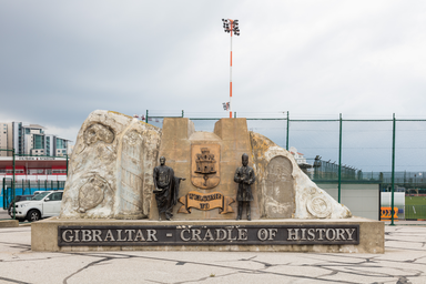
Monument called Cradle of History in northern Gibraltar, near coast.
Cradle of History is a monument in Gibraltar, a territory of the United Kingdom. It stands in the northern part of Gibraltar, about 2 meters above sea level and close to the sea. The surrounding area includes varied terrain with cliffs and caves within the wider region.
Cradle of History is a monument in Gibraltar, a territory of the United Kingdom. It lies in the northern part of Gibraltar, in the area of the country’s capital, and is identified in the GeoNames database with the identifier 10280713. The site is situated at an elevation of about 2 meters above sea level. The nearest larger urban area is Gibraltar itself, located approximately 0.68 kilometers to the south‑west. In its broader surroundings, within a radius noted in elevation data analyses, the landscape is described as varied. The highest nearby point reaches an elevation of about 292 meters and is situated around 1.1 kilometers to the south of Cradle of History. To the south‑east, the closest environment is the sea, indicating that the coastline is relatively near the monument. The region around Cradle of History is characterized by the presence of cliffs and caves, which are described as unusually common there compared with global averages. The monument is mapped with coordinates around latitude 36.15017 and longitude −5.34911, and appears on location maps of Gibraltar. Available references for Cradle of History draw on elevation information from Viewfinder Panoramas and geographic data from GeoNames.