Description
德国勃兰登堡州克劳斯尼克山脉中的最高山丘。
Wehlaberg是位于德国勃兰登堡州的山丘,是Krausnicker Berge的最高点,海拔144.1米。山顶设有观景塔,提供广阔的视野。该地区是受保护的自然保护区,吸引了许多徒步旅行者和自然爱好者。
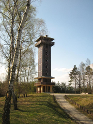
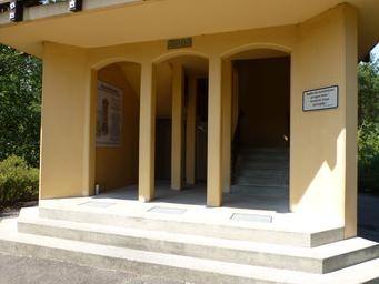
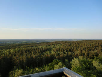
Wehlaberg位于德国勃兰登堡州的Krausnick-Groß Wasserburg,是Krausnicker Berge的最高点,海拔144.1米。它坐落在Spreewald生物圈保护区内,距离Köthen村约2公里,距离Krausnick和Groß Wasserburg分别约3.5公里和3.3公里。Wehlaberg的地质形成于Saaleeiszeit时期,主要由冰碛物、沙子和砾石构成。山顶上有一座建于2003年的28米高的观景塔,塔的下部为坚固的结构,上部为部分木制结构。游客可以通过混凝土和木制楼梯到达塔顶的观景平台,从24米高处俯瞰Krausnicker Berge和北部的Heideseen。在天气晴朗时,甚至可以看到58公里外的柏林电视塔。Wehlaberg也是一个受欢迎的徒步旅行目的地,欧洲远足径E10和Gurken-Radweg自行车道经过此地。此外,山顶东侧约600米处有一个移动通信运营商的发射塔和一个防火瞭望塔。Wehlaberg不仅是自然爱好者的理想去处,也是欣赏周围美景的绝佳地点。
Photos (3)
© Botaurus
·
Public Domain
© Muck
·
CC BY-SA 4.0
© Niesen
·
GNU Free Documentation License
Ratings
Fame:
30
Wow:
45
Ease of Access:
15
Physical Demand:
20
Safety:
10
Tourist Density:
35
Small hill with limited Wikipedia presence; primarily known locally within Brandenburg, Germany.
Offers panoramic views over the Spreewald and Köthener See; pleasant but not a jaw-dropping natural spectacle.
Located in rural Brandenburg, accessible by car or public transport from nearby towns like Köthen; standard tourist infrastructure available.
Easy walk to reach the observation tower with stairs leading up to viewing platforms; suitable for most visitors including families.
Germany is generally safe; this rural area has no significant natural or industrial hazards, low crime rate.
Local attraction with moderate footfall; popular among locals and some tourists but not a major international draw.
Location & Coordinates
52.058056, 13.801111